Home
AIRMoN
MDN
Search
Data
Maps
QA
Sponsors
Overview
Contacts
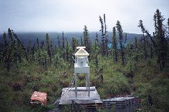
NADP/NTN Monitoring Location AK01
Station
Poker Creek (AK01)
Location
Fairbanks North Star Burough, Alaska
Dates of Operation
12/29/1992 - Present
Latitude
65.1547
Longitude
-147.4861
Elevation
230 meters
USGS 1:24000 Map Name
Operating Agencies
U.S. Forest Service - Pacific Northwest Research Station
University of Alaska Fairbanks
Sponsoring Agency
U.S. Forest Service
More Site Photographs
2006 Site Survey (11)
Large
Small
2002 Site Survey (11)
Large
Small
2000 Site Survey (4)
Large
Small
Miscellaneous (2)
Small
Site Survey Information
NADP/NTN Wet Deposition
Data Available
Trend Plots
Annual Data Summaries
Annual Data
data by calendar and water years
wet deposition totals
precipitation-weighted mean concentrations
Seasonal Data
wet deposition totals
precipitation-weighted mean concentrations
Monthly Data
precipitation-weighted mean concentrations
Weekly data
concentrations
Daily Data
daily precipitation data
External links related to this site
Clean Air Status and Trends Network (CASTNet)
CASTNet Site POF425 data
Comments and Suggestions
|
Use Conditions